Farrar's Island
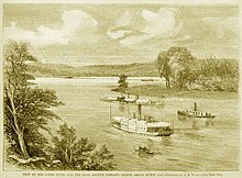
Peninsula in Chesterfield County, VirginiaFarrar's Island is a peninsula now on the west side of the James River in Chesterfield County, Virginia. The county operates the Dutch Gap Conservation Area and Boat Landing and as well as a living history museum, the Henricus Historical Park. Originally, Farrar's Island was formed by a meander loop in the James River and lay on the east side of the James River. At its smallest point, the neck of the peninsula was less than 400 feet wide. At that time, Farrar's Island was slightly less than 700 acres and lay about 15 miles (24 km) south of the James River fall line at Richmond, Virginia.
Read article
Top Questions
AI generatedMore questions
Nearby Places
CSS Hampton

Henricus
Archaeological site in Virginia, United States

Dutch Gap Canal
Battle of Ware Bottom Church
Part of the American Civil War in Virginia
Dutch Gap Canal Lights
Lighthouses in Virginia, United States

Battle of Trent's Reach
Battle of the American Civil War

Howlett Line
Dominion Energy Charity Classic
American professional golf tournament


